Friday, June 23, 2017

Grapevine Mountain

Hiked: 6/23/2017
Distance: 6.5 miles round trip on trail and cross country
Summit Elevation: 3955'
Prominence: 875'
Elevation Gain: 2058'
Elevation Gain (in Empire State Buildings): 1.64
Round trip time: 4 hours 20 minutes
Recommended water: 90 oz.
Parking/Fees: Free at turnout on San Felipe Road
Difficulty: Moderate

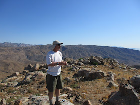
Grapevine Mountain sits above Scissors Crossing in San Diego County, #51 on the SDC list. After a week of debate on the wisdom of attempting a desert peak two days after the summer solstice, on a clear day, during an excessive heat warning, Mike Martin and I drove out to the Grapevine trailhead. I had vacillated on, then off, then on again with reservations. Mike seemed optimistic about the weather, but we didn't know if we were headed for trouble. The forecast called for a high in Borrego Springs of 114F, but only 97F in Ranchita. The high on Grapevine would likely fall somewhere between, but very hot in any case.

We arrived at the turnout off San Felipe Road and got started around 6:30 AM with a temp of 79F. Mike was OK with my suggestion to take a shortcut from the parking lot up the nearest ridge to intersect the PCT. This saved us a few tenths of a mile and maybe some time. Once on the PCT, we made good time in the shadow of Grapevine Mountain. By the time the sun edged over the mountain, we had reached the point where we needed to leave the trail. We picked our way up through the sharps, predominately cholla, barrel cactus, cats claw, and agave. After passing a couple of small bumps, we reached the crux, staring up at a false summit. Climbing this steep bump required about 500' of gain with some occasional light class 2. The upside was that while we climbed it, we were back in shadow and safe from the sun.


Start, shortcut on the left


Looking down the shortcut from the PCT


Looking north at the San Felipe Hills and Grapevine Hills


False summit on the right


Climbing the steep bump in the safety of shadow

From the top of the false summit, we got our first glimpse of Grapevine Mountain not far away and looking very attainable. In a short time, we reached the summit and admired the better than expected 360 views. Earthquake valley, the Palomar Observatory, Granite Mountain, Whale Mountain, Cuyamaca, and distant Toro were all visible from the perch we had on Grapevine. Mike and I signed the register and noted the obvious benchmark and two nearby reference marks. While the sharp things were omnipresent, fox tails proved more troublesome. I spent some time removing the grass and other debris that filled my socks and shoes. I had to repeat that exercise a few times before the day was over. Ankle gaiters would have helped. After I finished taking photos, I stumbled on a small summit boulder falling forward into the boulder in front of me. I stopped myself with my left shin and right palm. My shin immediately swelled a little and blood oozed from both spots but neither hampered my ability to move. There was more damage to my ego than anything else. A temp check indicated it was in the low 90s. We halfheartedly kicked around the idea of hitting provisional Peak 3813 on the way back but decided against it. The heat was going to increase.

On the way back, we scrambled down a gully to the PCT, slightly askew from our ascent track. The gully did offer deer or sheep bones and more light scrambling as entertainment. As we descended, the heat grew quite intense. We stopped for short breaks in the few shady places we found. Instead of taking the ridge shortcut down, we continued along the trail until it intersected a use trail back to the parking lot. Back at the car, the final temp check of the day read 111. It was probably a little high since the car had been sitting in the sun for a couple of hours. My guess is it was only in the low 100s. Still, skipping Peak 3813 turned out to be a good call since spending another 30-45 minutes in the rising heat would have been, at the very least, uncomfortable. On the drive back, I discovered one additional parting gift: a quarter inch thorn completely buried in my calf. I removed it with a combination of pliers and artful digging. Well worth it to push my P-index to 129.


Grapevine Mountain


Benchmark placed 1939


Mike on the summit


Sentenac, Whale Mountain, and Peak 3813


Grapevine Canyon and Highway 78


Mike took this 360 photo on the summit


Agave bloom


Deer or sheep bones in the gully


Wednesday, June 14, 2017

Hiking Pace and Naismith's Rule

This is a guest post by Professor Paul Pharoah, University of Cambridge.

William W Naismith was a Scottish mountaineer who regularly wrote for the Scottish Mountaineering Club Journal in the 19th Century – a hiking blogger of his day. In 1892 he wrote a paragraph about a hike on Cruach Ardran, Stobinian, and Ben More in the Scottish Highlands. He concluded with: “Distance, ten miles; total climb, 6,300 feet; time, six and a half hours (including short halts). This tallies exactly with a simple formula, that may be found useful in estimating what time men in fair condition should allow for easy expeditions, namely, an hour for every three miles on the map, with an additional hour for every 2,000 feet of ascent.”

Naismith's rule was intended to estimate the total duration of a walk, and as such walks usually start and end at the same point the total ascent will be the same as the total descent. It is generally assumed that the rule should apply to walking uphill and that average walking pace downhill is the same as walking on the flat, even though this is clearly not realistic. The rule is widely used in the mountain walking community in the UK, but it has never been evaluated in conditions or terrain outside the typical fells and mountains of England and Scotland.

Tobler was a Swiss mountaineer and used data from walking in the Swiss Alps to come up with a much more complicated formula that predicts walking pace that will vary depending on the uphill and the downhill gradient. His formula is:
Speed (km per hour) = 6*e {-3.5*abs(S + 0.05)}
where S is the slope of the climb which is negative for a downhill. It predicts a maximum speed of 6 km per hour or 10 minutes per km on a down slope of 5 per cent. For those who prefer miles to kilometers a 10 minute kilometer is a 16 minute mile. This seems to be more sensible as it is easier to walk fast on a gentle down slope, but then gets harder as the slope gets steeper.

The graph shows the predicted walking pace in minutes per kilometer predicted by the Naismith rule and the Tobler function depending on the slope or gradient.


The Naismith rule is widely used in the mountain walking community in the UK, but it has never been evaluated in conditions or terrain outside the typical fells and mountains of England and Scotland. Nor are there studies validating the Tobler function. The availability of GPS recordings of hikes makes it possible to test out the accuracy of the Naismith and Tobler functions using real data from typical hikers from around the world. Three sources of data were used: 49 hikes done in various places worldwide by PP (green), 19 hikes done by Iron Hiker on some of California's most well known peaks (blue) and a pseudo-random set of 98 recordings downloaded from the www.wikiloc.com GPS track sharing website (red). The location of these hikes are shown on the map below.


Latitude, longitude, elevation and time were extracted from each .gpx file and used to calculate the distance and duration of each recorded segment. Segments were then combined to give “chunks” of about 100 metres in length. The net elevation change for each chunk was then calculated as the elevation difference between the first and last point of the chunk. And so for each chunk the walking pace could be calculated and compared with the slope of the chunk. A total of 166 tracks comprising 22,343 chunks of about 100m and 2,242 km of hiking were included in the analysis. The average length of the hikes was 13.9km and the average ascent was 810m with 833m of descent. The next graph shows the walking pace against slope for the 22,343 chunks. Superimposed on the graph are the Naismith and Tobler functions together with a line of best fit (a multi-variable fractional polynomial for the record) based on the Wikiloc data.


The line of best fit confirms the U-shaped relationship between pace and gradient, with the fastest pace being for slopes of -7%. [emphasis - Ed.] This U-shaped relationship between slope and walking pace is more easily seen for all three data sets when the chunks are grouped together according to slope.


The next three graphs show the total walking time for each of the 166 hikes plotted against the total walking time predicted by the best fit function, by Naismith’s rule and by the Tobler function (blue dots are Wikiloc hikes, green are Iron Hiker hikes and pink are PP hikes. A perfect prediction would lie on the dashed line. The times are, of course, well predicted by the best fit function. The Naismith function does fairly well, tending to slightly over estimate time taken (most of the points are below the dashed line). On the other hand, the Tobler function significantly over estimates the hiking time.


We also investigated the effect of altitude on hiking pace, and found that every kilometer of altitude from sea level cost about 65 seconds per kilometer of travel, or for every 1000' of altitude the cost is about 32 seconds per mile. [emphasis - Ed.] Fatigue might also be expected slow us down, but in this data set there was little difference in walking pace at the start and end of the hikes. Of course many other factors will affect walking time including individual fitness, load carried, terrain, conditions underfoot (wet or snow and ice), weather (wind, temperature and humidity). But these could not be taken into account as the data were not available.

This analysis confirms what all hikers know. The speed at which you walk is affected by the slope of the hill and both steep uphill gradients and steep downhill gradients slow you down. We also know that hiking pace is affected by multiple other factors, but the Naismith rule developed over 100 years ago is a useful rule-of-thumb that gives a fairly accurate estimate of total hiking time for a wide range of conditions and terrains for typical hikers.

Saturday, June 10, 2017

Calamity Canyon Peak

Hiked: 6/9/2017
Distance: 11.2 miles round trip on road, trail, and cross country
Summit Elevation: 5800'
Elevation Gain: 3800'
Elevation Gain (in Empire State Buildings): 3.04
Round trip time: 9 hours 30 minutes
Recommended water: 120 oz.
Parking/Fees: Free on Haven Ave
Difficulty: Strenuous

Calamity Canyon Peak, at the head of Calamity Canyon, rises below Cucamonga Peak along a rugged south ridge. Other than a single attempt made 3/4/2012, I couldn't find any information on it. Here was Asher Waxman's account of the trip:
Peter Doggett, Janice Boyd and I approached from top of Haven Ave (2280'), up Deer Canyon to the Cucamonga Truck Trail (4900'), which is severely eroded in places and choked with buckthorn in the last 300' below the summit. From 5400' we tried the south ridge direct on remains of a trail shown on the topo. Impassable acres of buckthorn and manzanita effectively blocked that approach...so near. We back[ed] off to the the closed contour at 5560' and found the "road" at the left. With some energetic clipping and relatively clear sections we made it to ~5600'+, where passage was blocked...for now. Attaining the summit will require considerable clipping.
A group of us had been discussing making our own attempt and we met at Haven Ave in Rancho Cucamonga at daybreak. Sean, Henry, Steve and I started up a one mile paved section of road past water towers and several locked gates. Collectively, we were armed with two pair of clippers, a hatchet, and a saw. Past the last water tower, we took the dirt road into Deer Canyon. It stays mainly on the left side of the canyon, dipping in and out once before fading into the canyon for good. Some smiley faces were painted on a rocks in the canyon. Deer Canyon was a mix of sand, gravel, and granite boulders with a trickle of water in the upper reaches. When we reached the place where Calamity Canyon fed into Deer Canyon, I checked it out as a possible shortcut. We decided to continue to the West Cucamonga Truck Trail. Once we found it, we climbed up and away from Deer Canyon across dead fall and light brush. The trail was in pretty good shape until we approached the Calamity Canyon crossing. There were large washouts and loose rockfall on both sides of the canyon. I was tempted to drop into the canyon to bypass the washouts, but we stayed up on the trail. We got our first glimpse of the summit and after crossing the first washout, took a break directly above Calamity Canyon.


Henry on the road, Cucamonga Peak in the background


First section of Deer Canyon


Smiley face


Nearing the end of Deer Canyon


Start of the West Cucamonga Truck Trail


First sight of Calamity Canyon Peak

After considering the gully and the steep slope on the east ridge, we decided to continue as far as we could on the trail. The second washout crossing was a little sketchy, but we all made it without incident. The road started getting more overgrown with buckthorn and we had to break out the tools to start cutting through it. Ocassional dead branches were evidence of previous clipping. Eventually, we reached the south ridge where a short trail led up to a false summit. We spent about 10 minutes attempting to continue along the road but it was solid brush and we didn't know if there would be a pay off on the north side. We went up the south ridge trail to the false summit where we found a register with about a dozen entries dating back to 2012. From there, the true summit was only about 0.2 miles away and less than 300' above. The only thing between us and the summit was a moat of buckthorn and manzanita. It was a true Game of Thorns. We spent the next 2+ hours hacking, clipping, and sawing our way the top of Calamity Canyon Peak. We rotated fresh people to the front to keep our momentum going while everyone else cleaned up the path. The peak offered us a fair trade, blood for splinters.


Calamity Canyon and massive washouts


Steve and Henry crossing the biggest washout


Saddleback in the distance, above the haze


Henry clearing a nasty section of the road


Sean at the start of the south ridge, the sign reads Dead End


Hacking our way to Calamity


Nearing the summit

I packed up and moved the register from the false summit to the true summit. We built a new cairn in a small open area about 20' from the actual high point that was covered in brush. After the ordeal of getting there, we made the trivial effort of actually standing on the high point. I have high confidence we made the first ascent of this peak, certainly in the modern era. We got a group photo then enjoyed the amazing views of Ontario, Turtle's Beak, Peak 6786 and Cucamonga. It was somewhat hazy and smoggy toward the city, but Saddleback stood out above it. The descent back to the road went quickly now that we had blazed a trail. Sean found a rattlesnake while navigating the big washout during the return. I missed the snake by crossing too high. We debated trying a shortcut down Calamity Canyon. Henry and I decided to check it out while Sean and Steve continued down the road. We found a spot to drop into the canyon and it only looked like steep class 2 as far as we could see. However, after rounding a corner, we came to a 12' dry fall with a rotten rope anchored above it. The sheath on the rope was gone and exposed nylon fibers looked frayed. We might have been able to scramble down the fall, but another fall of unknown size loomed immediately ahead. We decided to head back up and not risk getting ourselves trapped between dry falls. Calamity Canyon would make a fun and relatively easy canyoneering trip. Henry and I climbed up a loose gully to get back to the road, sending several boulders crashing into the canyon. Eventually, we caught up with Sean and Steve and continued our descent.


(L to R) Henry, Sean, Keith, Steve


Turtle's Beak (left) and Ontario Peak


Peak 6786 and Cucamonga Peak


Fixed register with true summit elevation


New register cairn


Descending the trail we just cut


Dropping into Calamity Canyon


Turn around point, need a rope


Would you like to know more...?

Other Reports:
Sean's Report (EisPiraten)
Combined Photo Album